Endereço: 101 (From 101 To 199) W (West) WACO DR, WACO, TX 76707-38ND, USA
O que é o 76707-38ND? 76707-38ND é um número de CEP 5 Plus 4 de 101 (From 101 To 199) W (West) WACO DR, WACO, TX, USA. Abaixo estão as informações detalhadas.
🔺
The ZIP+4 code 76707-38ND is no longer in use, and the address no longer exists in the USPS ZIP+4 file database.
Todas as informações nesta página são historicamente arquivadas e fornecidas apenas para fins informativos.
76707-38ND Informação básica

Street Predirectional?
A geographic direction that precedes the street name.
| Rua?
The official name of a street as assigned by a local governing authority. The Street Name column contains only the street name and does not include directionals (EAST, WEST, etc.) or suffixes (ST, DR, BLVD, etc.). This element may also contain literals, such as PO BOX, GENERAL DELIVERY, USS, PSC, or UNIT. Numeric street names that have numeric components that are four characters (or less) in length at are justified such that the low-order digit of the number is positioned in the fourth position of the street name column. This shift is made so that the numeric street names appear in numeric sequence.
| Sufixo de rua?
The street suffix:
For Example:
ST = Street
RD = Road
DR = Drive
LN = Lane
| Cidade | Tipo de Registro?
An alphabetic value that identifies the type of data in the record. Record type codes include the following:
G = General delivery
H = Highrise
F = Firm
S = Street
P = PO box
R = Rural route/highway contract
| Status |
|---|---|---|---|---|---|
| DAVID | DR | WACO | S | válido | |
| KENTUCKY | AVE | WACO | S | válido | |
| N (North) | UNIVERSITY PARKS | DR | WACO | S | válido |
| W (West) | WACO | DR | WACO | S | válido |
Endereço

76707-38ND corresponde aos seguintes endereços.
| Lista de endereços | Status |
|---|---|
| 201 (From 201 To 299) DAVID DR, WACO, TX 76707-38ND, USA | inválido |
| 400 (From 400 To 498) KENTUCKY AVE, WACO, TX 76707-38ND, USA | inválido |
| 500 (From 500 To 598) KENTUCKY AVE, WACO, TX 76707-38ND, USA | inválido |
| 501 (From 501 To 599) KENTUCKY AVE, WACO, TX 76707-38ND, USA | inválido |
| 1001 (From 1001 To 1099) N (North) UNIVERSITY PARKS DR, WACO, TX 76707-38ND, USA | inválido |
| 101 (From 101 To 199) W (West) WACO DR, WACO, TX 76707-38ND, USA | inválido |
Endereço Exemplo
WACO TX 76707-38ND
UNITED STATES OF AMERICA
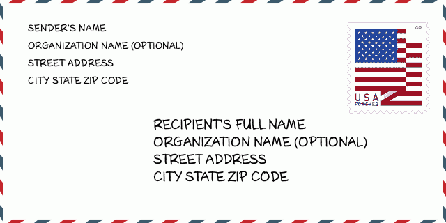
76707-38ND Exemplo de envelope

-
Este é um exemplo de envelope americano. Preencha as informações do remetente no canto superior esquerdo e as informações do destinatário no canto inferior direito. As informações necessárias são o nome completo do remetente / destinatário, endereço, cidade, estado e código postal. As informações do endereço do destinatário foram fornecidas para sua referência. Geralmente, se você não tiver certeza do código postal de 9 dígitos completo, só poderá preencher o código postal de 5 dígitos para evitar a perda do pacote.
76707-38ND Significado Básico
-
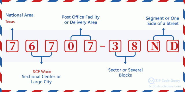
O que cada dígito do CEP 76707-38ND representa? O código ZIP + 4 consiste em duas partes, os primeiros cinco dígitos podem ser localizados na agência dos correios e os últimos quatro dígitos podem identificar um segmento geográfico dentro da área de entrega de cinco dígitos. Os 6 a 7 dígitos designam o setor ou vários blocos, e os 8 a 9 dígitos designam o segmento ou um lado de uma rua.

Mapa Online

Este é o mapa on-line do endereço 101 W (West) WACO DR, WACO. Você pode usar o botão para mover e fazer zoom in / out. As informações do mapa são apenas para referência.
Endereço: 101 (From 101 To 199) W (West) WACO DR, WACO, TX 76707-38ND, USA
Comment


Add new comment